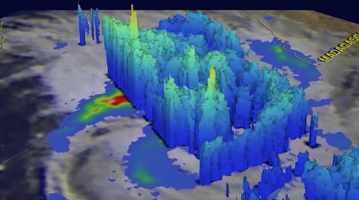
Tropical Storm Dineo was intensifying in the middle of the Mozambique Channel when NASA's GPM core observatory satellite flew over on February 14, 2017 at 0926 UTC.
Heavy rainfall of 100mm to 200mm per day is being forecast for southern Mozambique and parts of South Africa as they are hit by the formidable storm system.
READ MORE:
- LIVE: We track Dineo as storm heads to SAWe track the formidable storm system known as Dineo as it heads through Mozambique and prepares to strike parts of South Africa.
- Tropical storm Dineo - what to expect over the next 48 hoursHeavy rainfall of 100mm to 200mm per day is being forecast for southern Mozambique and parts of South Africa as they are hit by the formidable storm system known as Dineo.
- Cruise passengers party on‚ crew tests lifeboats as Dineo approachesCrew aboard the MSC Sinfonia cruise liner have been testing their lifeboats and changed their itinerary as cyclone Dineo approaches the Mozambique and South African east coasts.
- How tropical storm Dineo got her name - plus South Africa's Bransby is a real dudeTropical storm Dineo‚ which will soon reach cyclone strength‚ is a female and was named by Botswana's weather bureau.
- SA smack in tropical storm Dineo's sightsTropical storm Dineo is expected to escalate into an intense cyclone with thrashing winds within the next day.